22/5/2026
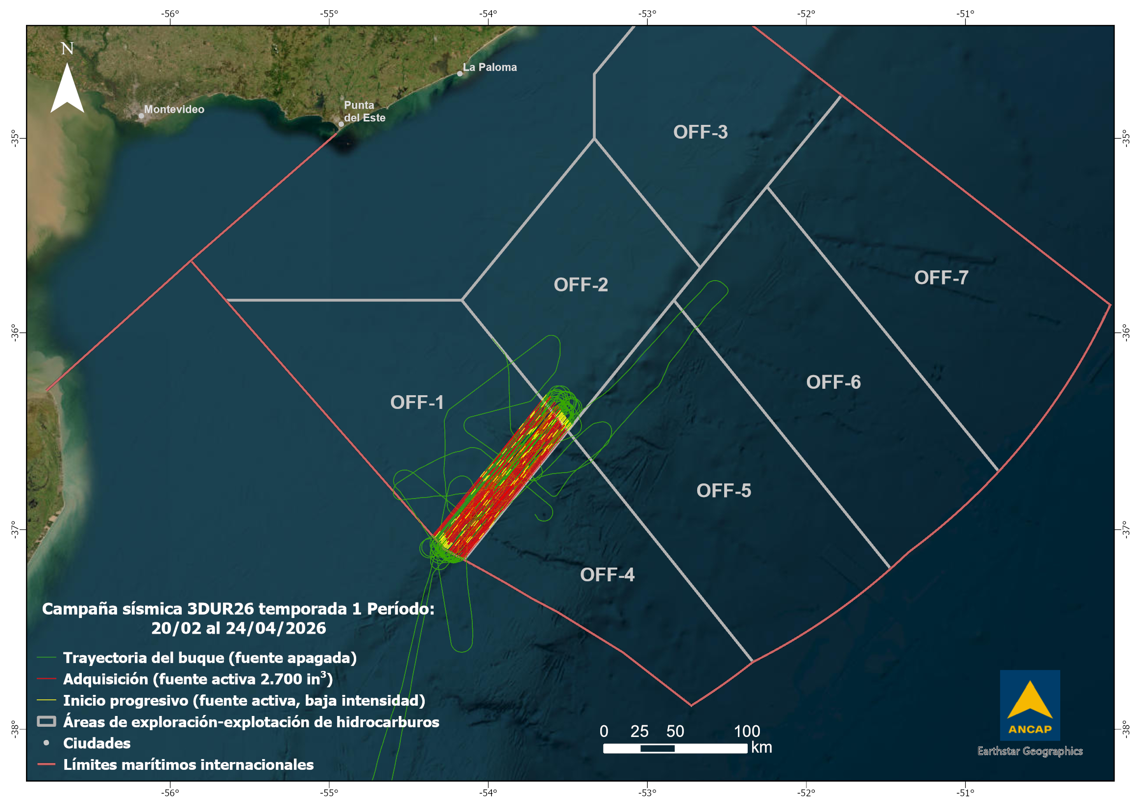
On April 23, the last data of the first season of the 3DUR26 seismic survey was acquired, reaching a final coverage of 1,400 km², with no environmental or health and safety incidents reported during its execution.
The survey was operated by CGG Services US Inc (Viridien) under a multi-client agreement with ANCAP, using the seismic vessel BGP Prospector, supported by the supply vessel Moonrise G and the Uruguayan-flagged chase boat WP Halle. Operations began on March 1 with the deployment of streamers, and the first data was acquired on March 7.
The project has environmental authorization under Ministerial Resolution No. 1482 of December 5, 2025, and its environmental management plan was approved by Ministerial Resolution No. 170 of February 27, 2026, issued by the Ministry of Environment.
The team of marine fauna observers began recording sightings on February 25 until the seismic vessel arrived at the Port of Montevideo on April 26. During this period, a total of 519 sightings and 148 detections of fauna through passive acoustic monitoring were reported. In 174 of these events, actions were taken to postpone the start of the source, and in 137 cases the source was shut down due to the presence of fauna within the mitigation zone. In the remaining sightings and detections, no action was necessary (source off or fauna outside the mitigation zone). Biweekly reports can be accessed at the Observatorio Ambiental Nacional.
This survey included a fisheries liaison officer (FLO) on board the supply vessel, with the aim of facilitating communication and coordination with fishing vessels. During the survey, a total of 4 Uruguayan trawlers were identified fishing at different distances from the seismic vessel.
Additionally, other activities committed in the environmental management plan were implemented: a biological monitoring cruise with the vessel B/P Promopes I (monitoring effects in ichthyoplankton and zooplankton and fish distribution, local abundance, and catch rates), measurement of sound levels and verification of the propagation model, implementation of a stranding response network along the coast, and a community engagement program.
The second season of this seismic survey is scheduled to begin in November this year in the OFF-1 and OFF-4 areas, with a combined total of around 7,000 km² across both seasons.
The map shows the trajectory of the seismic vessel between February 20 and April 24, indicating the positions where the source was activated for data acquisition (in red), for progressive start-up (low source intensity, in yellow), and line changes or navigation outside the area (source off, in green).